In a city in which cemeteries double as residences, where life and death can occupy the same spaces in myth and reality, the recent opening of Al Azhar Park on a site adjacent to the City of the Dead underlines the extant relationship between sacrality and recreation in Cairo. In the eighteenth century, Cairo was a walled city with specified sites of recreation. The two main recreational spaces frequented by families to celebrate mowlids (celebrations of saint’s birthdays), to have picnics, and to honor the dead, were the southern cemetery of the City of the Dead and the agricultural fields north of the city. Cairo spread to its present prodigious proportions in the early twentieth century, while its open spaces shrunk and its built spaces rapidly crept outwards. The prior tradition of open spaces converted into sites of gathering and recreation, is still reenacted today, though often in Lilliputian terms. Families are found picnicking upon slivers of land, traffic medians and the like, upon which some semblance of grass may be growing, providing a valuable, occupiable “green” space in an otherwise extremely dense and congested city. Wealthier families find more manicured, generous grounds to picnic upon in exclusive clubs.
Today Cairo boasts a new recreational site, Al Azhar Park, a seventy-four acre public green space replete with lush landscapes of fantastic plantings, scenic views, promenades, and Neo-Islamic architecture. The site lies beside the original grounds of the Fatimid royal city, the Ismaili dynasty that conquered Egypt in 969 AD/358 AH and upon an antique trash dump of 500 years. Its almost mythic landscape of groomed green mounds stands out lush and mirage-like against the backdrop of a city permanently dulled by the dun colored dust coating all its built surfaces. This uniform hue gives the city a visual conformity, which the park disrupts with its saturated tones. Visually distinct, the site is also physically discrete; it is an oblong shaped island whose boundaries are defined by infrastructure, roads and walls. Its western edge is divided from Darb Al Ahmar by the Ayyubid wall, while on its eastern front the site is separated from the City of the Dead by the Salah Salem highway. The exception to these distinct borders is the site’s southern edge, which directly abuts the City of the Dead, differentiated by having been an uninhabited landfill. These infrastructural devices reinforce the site’s location within an edge condition by segregating it from adjacent geographies. The sequestered site begs for either integration or reified distinctness.
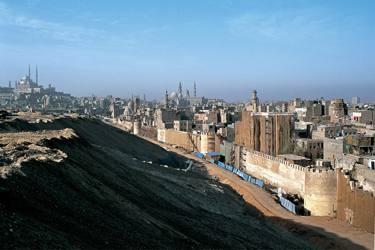
The park’s completion has not mediated the site’s edge condition but instead has complicated the reading of the park’s physical and social boundaries: to what and whom does it belong? The twelfth century Ayyubid wall discovered buried within the site had marked the eastern boundary of Salaheddin’s Cairo when it was built to protect the city from marauders, and established “outsiders,” by physically defining their exclusion from the city. At another point it separated the residential city from its cemeteries. Later it simply marked historical boundaries, separating Ayyubid Islamic Cairo from the Mamluk City of the Dead, until finally, over time it just disappeared under layers of refuse. The uncovered wall, 270 meters high and 3.5 meters wide, is now the western boundary of the park and marks a point of entry, inverting the original exteriority of the space beyond the wall into an exclusive site of interiority and otherness — socially, physically and architecturally.
A great success of the project remains its approach to the restoration of the Ayyubid wall. The Trust chose to preserve housing that was built along the wall, noting that the area’s Islamic urbanism was marked here by an organic growth and the integration of the wall with the lived-in surroundings. There are points where housing lies against, and even snakes over and rests upon, the wall. In one area a community center opens up onto the top of the wall, so the wall becomes a walkway, a striking proposition and inversion of figure and ground, both literally and conceptually. An alternate approach would have been to raze the housing and maintain a setback between future housing and the historic wall, a move that would be both historically inauthentic and less interesting. Engaging the structural and aesthetic nuances of how the housing rests upon or beside the wall, blurring the boundaries of monument and residence, and manipulating lines of vision through and over the site, are all provocative concepts. The subtleties and complexities of this endeavor present incredible architectural potential. Whether these potentials are realized inventively is another question, since these interventions that create spaces for Darb al Ahmar residents are not yet completed. The Salah Salem gate is currently the only operating entrance and only park workers use an open community entrance. Yet it is apparent that the park’s urbanism is sensitive to the particularities of Cairo’s history in its approach towards the Ayyubid wall, where the intertwined fabric of the residences and mosques is preserved as part and parcel of the history and essence of the monuments. It is here that the boundaries of the park become fuzzy, where Islamic Cairo rests atop the wall, with a favorable vantage point connecting it visually to the park, and brings in the inhabitants of Islamic Cairo.
The park’s essentialization of Islamic motifs, however, is problematic. Its planning relies primarily on an axial promenade, referencing Persian and Timurid influences, lined by royal palm trees — a surreal addition to such hilly topography since palm trees are found in river valleys and oases. This is acceptable if the concept behind the park was that in such an unnatural site, built upon a landfill, the site’s landscaping and architecture would celebrate its synthetic nature. But the design of the park contradicts this, it references a range of Islamic Cultures and their architectures but not self-consciously. The Hilltop Restaurant presents its diners with a voyeuristic view of Darb Al Ahmar below, whose labyrinthine streets virtually no restaurant-goer would ever find reason to wander. It sits at the northernmost apex of the promenade, while at its opposite end lies the lakeside restaurant. These buildings graft aesthetic elements from various Islamic cultures — Fatimid and Mamluk — but these qualities are superficially reproduced, not altered nor modified with new technologies nor spatial complexities. The buildings become weak resuscitations of inbred Islamic architectures, without infusing new meanings. It is here that the park has lost a unique opportunity, what with the profiles of the regal, squat, Turkish style citadel and the more nuanced minarets of the Mamluk-era Madrasa of Sultan Hassan visible in the distant southern horizon. These monuments evoke the grandeur of previous Islamic architectural eras; against such delicate and visionary work, the project’s constructions fall flat. Nevertheless, such a failure is hardly to be attributed to the Islamic world’s refusal of western modernity, rather the park is interested in compressing version of historical time into a packaged environment. Instead the goal of the work should be innovation, architectural styles of the region could be tapped into and innovated upon, instead of dressing boxes with Islamic features in an attempt to lend the architecture regional authenticity.
The pastoralism of the park belies the urban and layered character of the site. The buildings do not take advantage of the unusual topography of the site, the only hilly region in all of Cairo besides the Mu'attam. Because the site is ideally sited on a landfill, an archaeological site embedded with remnants of antique ceramic shards, the park could speak to the historical layering of the location and Islamic Cairo as a whole. Yet the buildings do not engage with the ground but perch lightly upon it. Seemingly unaware of the site’s slopes, no effort is made to cut sectionally into it, instead maintaining simple figural relationships to the ground plane. Furthermore, the park promenade as it exists could be transplanted to a different location without any disruption, with the exception of the southern lookout, a viewing point that affords a breathtaking view of the city and its monuments. The impression of the park from afar is more that of the ground functioning as a plinth upon which the palm trees and architecture rise up as figure. The result is a simple reading and trite experience of the park.
Despite the park’s failure to integrate the site into some urban fabric or exaggerate its fantastic character along with its hackneyed architectural references, the physical presence of the park and the Trust’s joint interest in design and development is incontestably impressive. Their argument is inherently one that prioritizes people and admits that the success of urban development in the inhabited historic district can only occur in conjunction with social and economic development aimed at its inhabitants. Yet such commitments and ideologies must manifest themselves spatially in order to be effective.